Massive Wedge Tornado Moves Through Iowa
Summary
TLDRThe transcript describes a dramatic scene of a massive wedge tornado tearing through an interstate in Nebraska, causing major damage. The narrator expresses astonishment at the size and intensity of the tornado, noting its violent nature as evidenced by the wind's force and the debris it carries. The video captures the tornado's inflow, with the wind's speed illustrated by the way it kicks up water and debris. The scene also includes a comparison to driving in heavy rain, emphasizing the difficulty of comprehending the tornado's scale from a distance. The potential for damage is highlighted by the sight of a tree stripped of its branches and leaves, likely due to the tornado's powerful suction. The summary aims to convey the urgency and awe-inspiring power of the natural disaster.
Takeaways
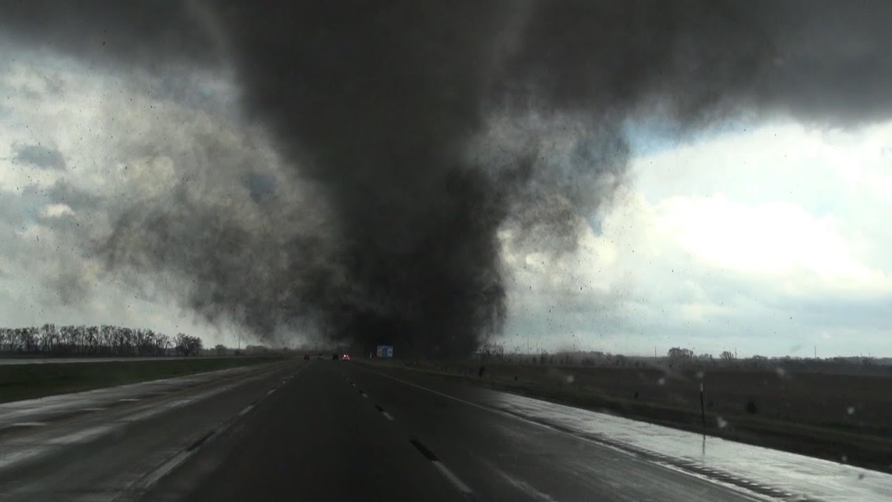
- 🌪️ A massive wedge tornado has taken over an entire interstate, causing chaos and major damage.
- 📍 The tornado is located in Harlan, Iowa, with significant destruction observed in the area.
- 🚨 The tornado's violent nature is evident from the wind speed and debris being thrown around.
- 🌬️ The wind is so strong that it's carrying water off the roads, similar to driving after heavy rain.
- 🌳 Trees near the tornado have been stripped of branches and leaves, indicating the intensity of the tornado's inflow.
- 🚗 Traffic has been forced to stop due to the intensity of the wind and the risk of flying debris.
- 📊 The tornado is estimated to be between 3 to 4 miles wide, which is unusually large for a tornado.
- 🔍 The radar is being used to measure the distance from the tornado and to discuss the wind speed at that distance.
- 🌀 The inflow and circulation of the wind around the tornado are highlighted, showing its powerful suction effect.
- 🏞️ The script describes the scene as being difficult to fathom, emphasizing the scale and power of the tornado.
- ⚠️ There is a concern for potential damage in the foreground, with the tornado's impact on the landscape being severe.
Q & A
What kind of weather event is being described in the transcript?
-A massive wedge tornado is being described, which has taken over an entire interstate.
What is the location where the tornado is occurring?
-The tornado is occurring in Harlan, Iowa.
What is the scale of the tornado mentioned in the transcript?
-The tornado is estimated to be between 3 to 4 miles wide.
What is the impact of the tornado on the environment as described?
-The tornado is causing major damage, with trees snapped and debris being thrown across the road.
How is the wind speed associated with the tornado?
-The wind speed is very high, causing water to be kicked up and carried away by the wind, and debris to be spit through the air.
What is the situation with traffic due to the tornado?
-Traffic has been forced to stop due to the intensity of the wind and the danger posed by the tornado.
What is being illustrated in the foreground of the video?
-In the foreground, an SUV is seen with water being kicked up around it, indicating the high wind speeds.
What is the role of the banner team in the context of the video?
-The banner team is likely responsible for providing live updates and visuals of the tornado, possibly from a safe distance.
What does the phrase 'wedge tornado' refer to?
-A wedge tornado refers to a large, wide tornado that has a wedge-shaped appearance, indicating its massive size and potential for causing significant damage.
How is the inflow of the tornado described?
-The inflow of the tornado is described as the wind getting sucked in like a vacuum, illustrating the powerful suction effect of the tornado.
What is the concern expressed about the trees in the video?
-The concern is that trees near the tornado have lost their branches and leaves, indicating the violent nature of the tornado and its ability to strip trees bare.
What is the purpose of checking the radar in the video?
-The purpose of checking the radar is to measure the distance from the tornado and discuss the wind speed from that distance, providing a better understanding of the tornado's impact.
Outlines
🌪️ Massive Wedge Tornado Overtakes Interstate
The video script describes a chaotic scene with a massive wedge tornado that has taken over an entire interstate. The speaker expresses astonishment at the size and power of the tornado, noting they have never seen anything like it before. The tornado is causing major damage and has traffic forced to a halt due to the intensity of the wind. The video includes observations of the tornado's inflow, the wind's violent nature, and the debris being carried across the road. The speaker also discusses the difficulty of comprehending the scale of the tornado and its effects, comparing the experience to driving in heavy rain where water is pushed across the windshield by the wind.
Mindmap
Keywords
💡Chaotic
💡Massive Wedge Tornado
💡Interstate
💡Major Damage
💡Wind Speed
💡Destructive
💡Nebraska
💡Inflow
💡Debris
💡Radar
💡Tornado
Highlights
Chaotic situation described since the event began.
Massive wedge tornado taking over an entire interstate.
Witnessing a tornado in Harlan, Iowa.
Destructive tornado tearing through Nebraska with high wind speeds.
SUV seen kicking up water, indicating the force of the wind.
Major damage caused by the tornado.
Traffic has stopped due to the intensity of the wind.
Debris being raked across the road and spit through by the wind.
Wide view of the wedge tornado showing its size and inflow.
Estimation of the tornado's size at 3 to 4 miles wide.
Concern for potential damage as trees lose branches and leaves.
Illustration of how fast the wind is wrapping and circulating around the tornado.
Visual of the wind carrying water off the roads.
Comparison of the tornado's impact to driving after rain with water being pushed through.
Request to bring up the radar to measure the distance from the tornado.
Concern for the violent nature of the tornado and its potential impact.
Remark on the difficulty of comprehending the scale of the tornado.
Transcripts
AND IT'S JUST IT'S BEEN
CHAOTIC EVER SINCE THEN.
COREY, WE'RE GOING TO
TALK TO YOU, IN JUST A
LITTLE BIT. WE GOT TO GET
INTO THIS. THIS IS A
MASSIVE WEDGE TORNADO
THAT'S JUST TAKEN OVER AN
ENTIRE INTERSTATE. THIS.
I'VE NEVER SEEN ANYTHING
LIKE THIS. WE'RE GOING TO
COME BACK, CHECK WITH
YOU. I KNOW YOU'RE
CHASING THIS AS WELL. AND
THERE HAS BEEN SADLY
MAJOR DAMAGE OUT OF THIS.
AND SO WE'LL WE'LL CHECK
IN WITH YOU. THANK YOU
FOR ALL THE HARD WORK. WE
GOT TO GET INTO THIS TEAM
AND LOOK AT THIS. IF WE
CAN. YEAH. LET'S START
ILLUSTRATING OVER AND
SHOWING YOU BRETT ADAIR,
THIS IS NOW IN HARLAN,
IOWA. WE WERE SHOWING YOU
THAT CITY. IT WAS JUST TO
THE WEST OF THERE. LOOK
AT THIS. THIS THING RIGHT
HERE. NOW YOU'RE
WITNESSING IN FRONT OF
YOU IS A TORNADO. I KNOW
IT'S TOUGH TO EVEN
FATHOM. I, WHILE TALKING
TO COREY, LOOK AT THE BY
THE WAY, IN THE
FOREGROUND, THE WIND
SPEED. YOU SEE THIS SUV
THAT'S KICKING UP THE
WATER, IF WE CAN DROP THE
BANNER TEAM REAL QUICKLY.
DESTRUCTIVE TORNADO IS
TEARING THROUGH NEBRASKA.
LOOK AT HOW FAST THE WIND
IS. LIKE SPITTING THAT
OFF THE ROAD. THAT'S
SPEAKING TO THE VIOLENT
NATURE THIS FAR REMOVED
FROM THE TORNADO. IMAGINE
BEING IN THAT TORNADO,
THOUGH, AND WHAT'S OUT
AHEAD OF THIS? STEVE,
LOOK AT THAT TREE AHEAD
OF THAT CAR AND HOW IT'S
LEANING. IT'S JUST
SNAPPED RIGHT TO THE SIDE
. KEN, I DON'T KNOW EVEN
HOW TO TALK ABOUT THIS
RIGHT NOW. WE'RE LOOKING
AT THIS ON TELLY. THIS
RIGHT HERE IS SHOWING YOU
HOW WIDE. SO IT GOES FROM
HERE TO HERE. ALL OF THIS
IN BETWEEN IS A TORNADO A
WEDGE TORNADO THAT IS
COMING DOWN AS OF RIGHT
NOW. AND AS WE ZOOM IN,
LOOK AT THIS. THIS IS
SHOWING YOU THAT INFLOW
AND HOW THE WIND IS JUST
GETTING SUCKED IN LIKE A
VACUUM. I MEAN, I'VE
NEVER SEEN ANYTHING THIS
LARGE BEFORE. AND IT'S
TOUGH TO FATHOM THAT THIS
WOULD BE CLASSIFIED AS A
TORNADO. I MEAN, IT'S
MUCH LARGER. YOU THINK, I
MEAN, WHEN WE HAD THIS
ESTIMATED BEFORE 3 TO 4
MILES, YOU CAN TELL THE
TRAFFIC HAS STOPPED HERE.
EVERYBODY HAS BEEN FORCED
TO STOP. THEY DO NOT WANT
TO GET ANY CLOSER TO THIS
BECAUSE OF THE INTENSITY
OF THE WIND. NOTICE THE
DEBRIS RIGHT HERE. THIS
IS WHY THEY'RE STOPPING,
IS BECAUSE THE DEBRIS
THAT THIS HAS ALREADY
CAUSED AND IT'S RAKING IT
ACROSS THE ROAD AND
SPITTING IT THROUGH. I
WANT YOU TO LOOK RIGHT IN
HERE. THIS IS IN THE MID
LEVELS OF THE ATMOSPHERE.
JUST SHOWING YOU HOW FAST
THE WIND IS WRAPPING
AROUND AND CIRCULATING
AROUND THIS. AGAIN YOU
CAN WITNESS AS THIS SUV
PULLS AHEAD, SEE HOW FAST
THE WIND IS CARRYING THAT
WATER OFF OF THE ROADS.
EVERYBODY AT HOME. YOU
MAY NOT BE ABLE TO FATHOM
A TORNADO, BUT YOU CAN
FATHOM WHAT IT'S BEEN
LIKE TO DRIVE AFTER RAIN
IS PUSHED THROUGH AND THE
WATER USUALLY SPITS UP
INTO YOUR WINDSHIELD, YOU
DON'T EVEN HAVE TO USE
THE WINDSHIELD BECAUSE
THE WIND IS CARRYING IT
AWAY. AND WE ARE TALKING
ABOUT HOW MASSIVE A
DISTANCE AWAY WE ARE FROM
THIS EVENT. CAN WE BRING
UP THE RADAR? CAN YOU
MEASURE? SAM? I SEE YOU
HAVE BRETT THERE. CAN YOU
MEASURE HOW FAR AWAY HE
IS FROM THE TORNADO? SO
WE CAN TALK ABOUT HOW
FAST THE WIND IS FROM
THIS DISTANCE AWAY. NOW
LOOK IN THE FOREGROUND
HERE. THIS IS WHERE
YOU'RE STARTING TO WORRY
ABOUT POTENTIAL DAMAGE.
YOU HAVE THIS TREE THAT
NO LONGER HAS ANY TYPE OF
BRANCHES OR LEAVES. IF
YOU LOOK AT THE TREES
AROUND IT, IT DOES. WHICH
MEANS THIS GOT SUCKED
AWAY AND RIPPED APART AS
THIS TORNADO
5.0 / 5 (0 votes)


